
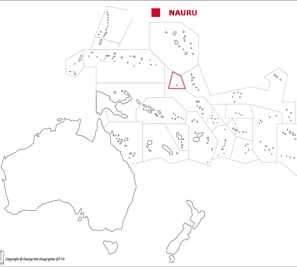
Where is Nauru?
About Nauru
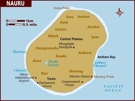
The Land
The People
Life and Death
Health, Energy and the Environment
Education and Work
Travel, Communication and the Media


Back to the Flags of Oceania page


Nauru is an island country in Oceania. Together with 4 other countries it forms an island group known as Micronesia.
Nauru is in the Pacific Ocean.
The island is mainly flat with a small central plateau.
The geographical coordinates for the centre of Nauru, also known as lines of latitude and longtitude, are:-
Latitude - 0 32S
Longitude - 166 55E

Check the weather in Yaren now. Yaren is the administrative centre.
This is the time in Yarem now
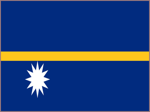 The Nauruan flag is blue with a narrow.
horizontal, gold stripe across the centre. A white 12 pointed star is below the gold stripe on the flag pole side. The gold stripe and white star represent Nauru's
position just below the equator while the 12 points of the star are for the original 12 tribes of the island.
The Nauruan flag is blue with a narrow.
horizontal, gold stripe across the centre. A white 12 pointed star is below the gold stripe on the flag pole side. The gold stripe and white star represent Nauru's
position just below the equator while the 12 points of the star are for the original 12 tribes of the island.
Nauru has no capital city.
Nauru is a parliamentary republic with a President as head of government and head of state.
In elections everyone over the age of 20 must vote.
The currency in the Nauru is the Australian dollar. Nauru is a member of the Commonwealth.
Nauruan is the official language.
Hear the National Anthem
These are the anthem words
We have already written our own history of England but are asking schools in Nauru to provide us with a detailed history of
their own country. Check how here.
![]()
![]() Back to the top
Back to the top

The total land area of Nauru is 21 sq kms which is the 14th largest in Oceania.
Nauru has no lakes, rivers and canals.
Nauru has no boundaries with other countries.
Nauru has a coastline of 30 kms which is the 13th longest in Oceania.
The highest point in Nauru is Command Ridge at 70 metres.
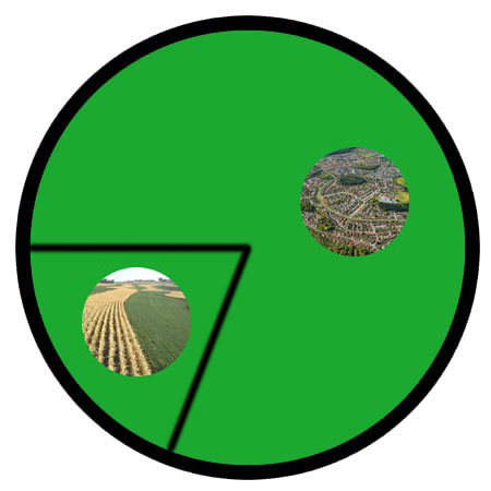
The pie chart below shows how the land is split between agricultural land (crops and pastures), forests and other, which can be towns, villages, desert or frozen waste called tundra.

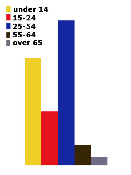
The total population of Nauru is 9,642 people, making it the 14th largest country in Oceania by population.
Of this number 5,105 are females and 4,537 are males.
A person from Nauru is called a Nauruan.
We have no information about citizenship in Nauru.
The largest four cities in Nauru, by population are:-
- Arijejen 2,381 people
- Menen 1,400
- Yaren District 1,100
- Boe 950
For each country we will give you a diagram showing the population density. This is the average number of people for each square kilometre.
 Each little Owlbut is 1 person and
the big yellow rectangle is 1 sq km. After a while you can compare countries and see which ones are the most crowded. Remember it is only an average as
more people live closer together in towns and cities than in villages out in the country.
Each little Owlbut is 1 person and
the big yellow rectangle is 1 sq km. After a while you can compare countries and see which ones are the most crowded. Remember it is only an average as
more people live closer together in towns and cities than in villages out in the country.
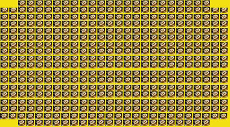
100.0% of the people live in cities or towns.
Each little Owlbut is 1 person and
the big yellow rectangle is 1 sq km. After a while you can compare countries and see which ones are the most crowded. Remember it is only an average as
more people live closer together in towns and cities than in villages out in the country.
100.0% of the people live in cities or towns.

The birth rate in Nauru is 24.4 births per 1,000 of population
The death rate in Nauru is 5.9 deaths per 1,000 people.
Check this against the birth rate. If the death rate is higher than the birth rate then
the population will decrease unless immigrants arrive in the country.
There are 6.1 deaths of girls under 1 year per 1,000 of births and 10.2 deaths of boys.
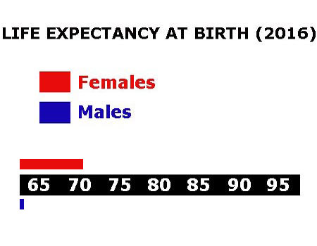
The median age for females is 25.5 and for males is 26.5. The median age is that age which divides the population exactly in half so there are the same number
of people above the median age as below it.
The average age of a woman when she has her first child is 22.1.
The elderly dependency ratio is 4.3. This is the number of elderly people (ages 65+) per 100 people of working age (ages 15-64).
The potential support ratio is 23.1. This is the number of working-age people (ages 15-64) per one elderly person (ages 65+). As a population ages, the potential support ratio tends to fall, meaning there are fewer potential workers to support the elderly.

Nauru spends 3.3% of its total income on health care.
There are 0.71 doctors per 1,000 people.
There are 5.0 hospital beds per 1,000 people.
61.0% of the population are estimated as obese.
96.5% of the population have drinking water that is either piped into their home or they have access to a public tap, a protected borehole, well, spring or
protected rainwater collection facility.
65.6 of the population have access to a flushing toilet that is connected to a sewer. a pit latrine (that is a
permanent hole in the ground that is looked after) or a composting toilet.
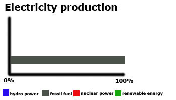
Nauru releases 0.2 million metric tons of carbon dioxide by burning fossil fuels in the process of producing and consuming energy. This puts it as the 13th highest in Oceania.

We have no figures for the amount Nauru spends of its total income on education.
Children usually start school at age 6 in Nauru. Primary education is for six years until age 12 and secondary education must continue till 17 but can
go on to 18/19. There are no further education possibilities on Nauru.
We are awaiting information on the school terms in Nauru.
We have no figures for the number of people who are able to read and write by the age of 15.
We have no figures for the number of people aged between 16 and 24 who are not in work.
We have no figures for the total number of people available for work in Nauru.
23.0% of the workforce are unemployed.

There is 1 paved airport in Nauru, which is the 12th highest number in Oceania.
![]()
There are no railways in Nauru.
![]()
There are 30 kilometres of roads in Nauru, which means Nauru is in 12th place for the most kilometres of roads in Oceania.
![]()
There are no major national newspapers in Nauru.
There are 9,900 mobile phone users.
14% of the people have a fixed landline.

5,100 people have access to the internet at home via any device (computer or mobile).