
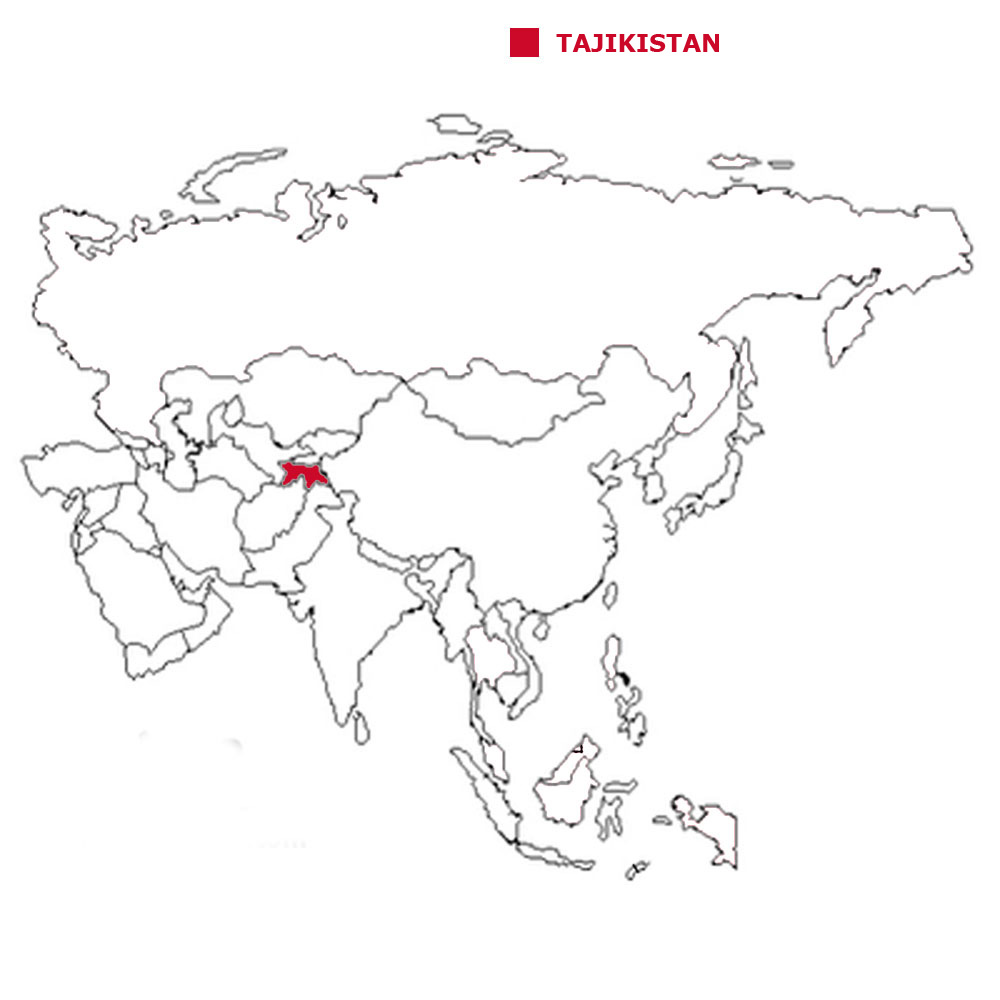
Where is Tajikistan?
About Tajikistan
The Land
The People
Life and Death
Health, Energy and the Environment
Education and Work
Travel, Communication and the Media


Back to the Flags of Asia page

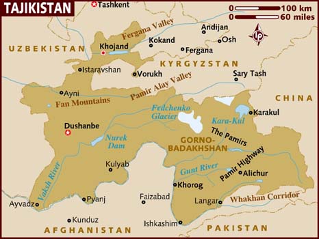

Tajikstan is above average size country in central Asia.
Tajikstan is a landlocked country with no coastal border.
The land is a mixture of mountains and valleys.
The geographical coordinates for the centre of Tajikistan, also known as lines of latitude and longtitude, are:-
Latitude - 39 00N
Longitude - 71 00E

Check the weather in Dushanbe now.
This is the time in Dushanbe now.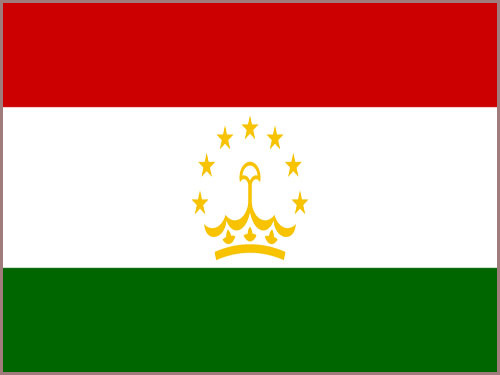 The Tajikistani flag is 3 horizontal
stripes of red, at the top, a wider central stripe of white and a lower stripe of green.
The Tajikistani flag is 3 horizontal
stripes of red, at the top, a wider central stripe of white and a lower stripe of green.
The capital of Tajikistan is Dushanbe.
Tajikistan is a presidential republic with a president as head of state and as head of the government.
In elections everyone over the age of 18 can vote.
The currency in Tajikistan is the Tajik somoni.
Tajik is the official language.
Hear the National Anthem
These are the anthem words
Tajikistan is a presidential republic with a president as head of state and as head of the government.
In elections everyone over the age of 18 can vote.
The currency in Tajikistan is the Tajik somoni.
Tajik is the official language.
Hear the National Anthem
These are the anthem words
We have already written our own history of England but are asking schools in Tajikistan to provide us with a detailed history of
their own country. Check how here.
![]()
![]() Back to the top
Back to the top

The total land area of Tajikistan is 141,510 sq kms which is the 28th largest in Asia.
Tajikistan has boundaries with 4 countries
- Afghanistan 1,357 kms
- Uzbekistan 1,312 kms
- Kyrgyzstan 984 kms
- China 477 kms
Tajikistan has no coastline.
The highest point in Tajikistan is Qullai Ismoili Somoni at 7,495 metres.
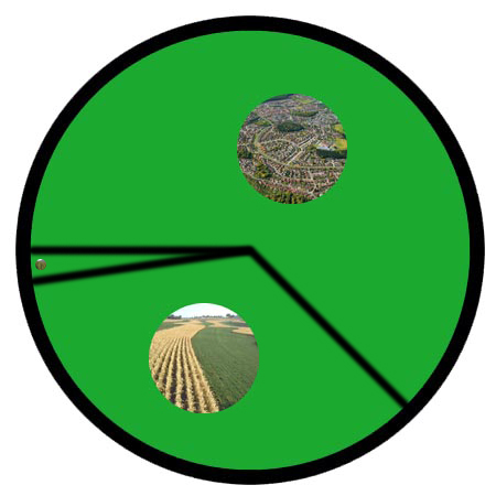
The pie chart below shows how the land is split between agricultural land (crops and pastures), forests and other, which can be towns, villages, desert or frozen waste called tundra.

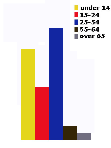
The total population of Tajikikstan is 8.33 million people, making it the 29th largest country in Asia by population.
Of this number 4.19 million are females and 4.14 million are males.
A person from Tajikistan is called a Tajikistani.
To be a citizen of Tajikistan, one of your parents must be a citizen of Tajikistan. It is not sufficient to be born in Tajikistan. You have to live in Tajikistan for
5 years before you can begin to apply for citizenship.
The largest five cities in Tajikistan, by population are:-
- Dushanbe 679,400 people
- Khujand 144,865
- Kulob 78,786
- Kurgan-Tyube 65,000
- Istaravshan 52,850
For each country we will give you a diagram showing the population density. This is the average number of people for each square kilometre.
 Each little Owlbut is 1 person and
the big yellow rectangle is 1 sq km. After a while you can compare countries and see which ones are the most crowded. Remember it is only an average as
more people live closer together in towns and cities than in villages out in the country.
Each little Owlbut is 1 person and
the big yellow rectangle is 1 sq km. After a while you can compare countries and see which ones are the most crowded. Remember it is only an average as
more people live closer together in towns and cities than in villages out in the country.

26.8% of the people live in cities or towns.
Each little Owlbut is 1 person and
the big yellow rectangle is 1 sq km. After a while you can compare countries and see which ones are the most crowded. Remember it is only an average as
more people live closer together in towns and cities than in villages out in the country.
26.8% of the people live in cities or towns.

The birth rate in Tajikistan is 23.8 births per 1,000 of population
The death rate in Tajikistan is 6.1 deaths per 1,000 people.
Check this against the birth rate. If the death rate is higher than the birth rate then
the population will decrease unless immigrants arrive in the country.
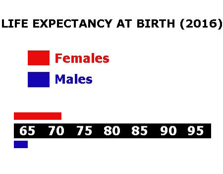
There are 28.4 deaths of girls under 1 year per 1,000 of births and 37.1 deaths of boys.
The median age for females is 25.1 and for males is 23.9. The median age is that age which divides the population exactly in half so there are the same number
of people above the median age as below it.
The average age of a woman when she has her first child is 22.9.
The elderly dependency ratio is 5.4. This is the number of elderly people (ages 65+) per 100 people of working age (ages 15-64).
The potential support ratio is 18.5. This is the number of working-age people (ages 15-64) per one elderly person (ages 65+). As a population ages, the potential support ratio tends to fall, meaning there are fewer potential workers to support the elderly.

Tajikistan spends 6.9% of its total income on health care.
There are 1.92 doctors per 1,000 people.
There are 5.5 hospital beds per 1,000 people.
14.2% of the population are estimated as obese.
93.1% of the urban population and 66.7% of the rural population have drinking water that is either piped into their home or they have access to a public tap, a protected borehole, well, spring or
protected rainwater collection facility.
93.8% of the urban population and 95.9% of the rural population have access to a flushing toilet that is connected to a sewer. a pit latrine (that is a
permanent hole in the ground that is looked after) or a composting toilet.
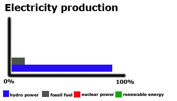
Tajikistan releases 3.7 million metric tons of carbon dioxide by burning fossil fuels in the process of producing and consuming energy. This puts it as the 45th highest in Asia.

Tajikistan spends 5.2% of its total income on education.
Children usually start school at age 7 in Tajikistan. Primary education is for four years until age 11 and secondary education must continue till 16 but can go on to 18/19. This may be followed
by further education at a university or college.
We are awaiting information on school terms in Tajikistan.
99.7% of females and 99.8% of males are able to read and write by the age of 15.
16.7% of all people aged between 16 and 24 are not in work. Among females 13.7% are unemployed while with males 19.2% can't find work.
The total number of people available for work in Tajikistan is 2.30 million.
 They work in the following sectors.
- Agriculture includes farming, fishing and forestry work
- Industry includes mining, manufacturing, construction and energy workers
- Services is everything else

There are 17 paved airports in Tajikistan, which is the 29th highest number in Asia.
![]()
There are 680 kilometres of railways in Tajikistan, the 30th longest in Asia.
![]()
There are 27,767 kilometres of roads in Tajikistan, which means Tajikistan is in 24th place for the most kilometres of roads in Asia.
![]()
There are 1 major national newspaper in Tajikistan.
There are 9.40 million mobile phone users.
6% of the people have a fixed landline.

1.71 million people have access to the internet at home via any device (computer or mobile).